irss-ai-publications.github.io
Integrate Remote Sensing Studio AI Publications

Tree Delineation and Species Classification from UAV Imagery
Chadwick, A., Coops, N., Bater, C., Martens, L., White, B., 2024. Transferability of a Mask R-CNN model for the delineation and classification of two species of regenerating tree crowns to untrained sites. SCIENCE OF REMOTE SENSING 9. https://doi.org/10.1016/j.srs.2023.100109
Chadwick, A., Coops, N., Bater, C., Martens, L., White, B., 2022. Species Classification of Automatically Delineated Regenerating Conifer Crowns Using RGB and Near-Infrared UAV Imagery. IEEE GEOSCIENCE AND REMOTE SENSING LETTERS 19. https://doi.org/10.1109/LGRS.2021.3123552
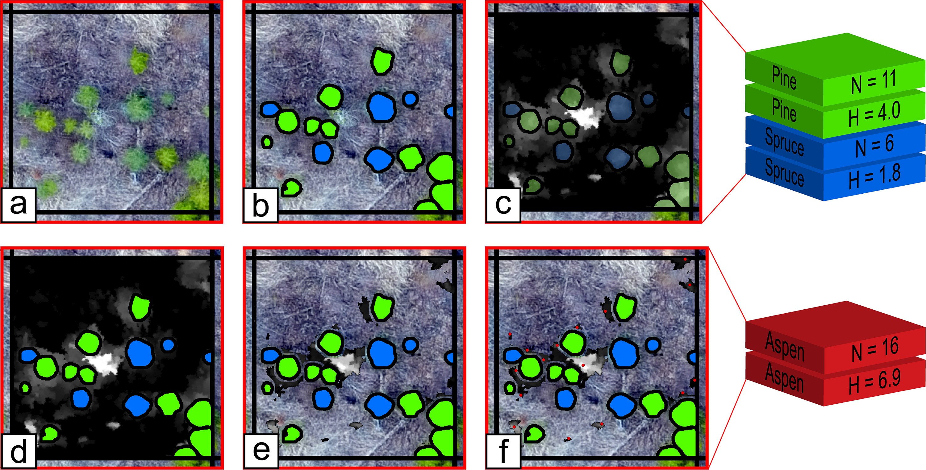
Chadwick, A., Goodbody, T., Coops, N., Hervieux, A., Bater, C., Martens, L., White, B., Röeser, D., 2020. Automatic Delineation and Height Measurement of Regenerating Conifer Crowns under Leaf-Off Conditions Using UAV Imagery. REMOTE SENSING 12. https://doi.org/10.3390/rs12244104
Chadwick, A.J., Coops, N.C., Johnson, K.M., Bater, C.W., Martens, L.A., Röeser, D., White, B., 2025. A remote sensing methodology for sub-stand growth and yield projection of post-harvest forest regeneration. Forestry: An International Journal of Forest Research 98, 454–463. https://doi.org/10.1093/forestry/cpae051
Biomass Estimation from Airborne Laser Scanning Data
Seely, H., Coops, N.C., White, J.C., Montwé, D., Winiwarter, L., Ragab, A., 2023. Modelling tree biomass using direct and additive methods with point cloud deep learning in a temperate mixed forest. Science of Remote Sensing 8, 100110. https://doi.org/10.1016/j.srs.2023.100110
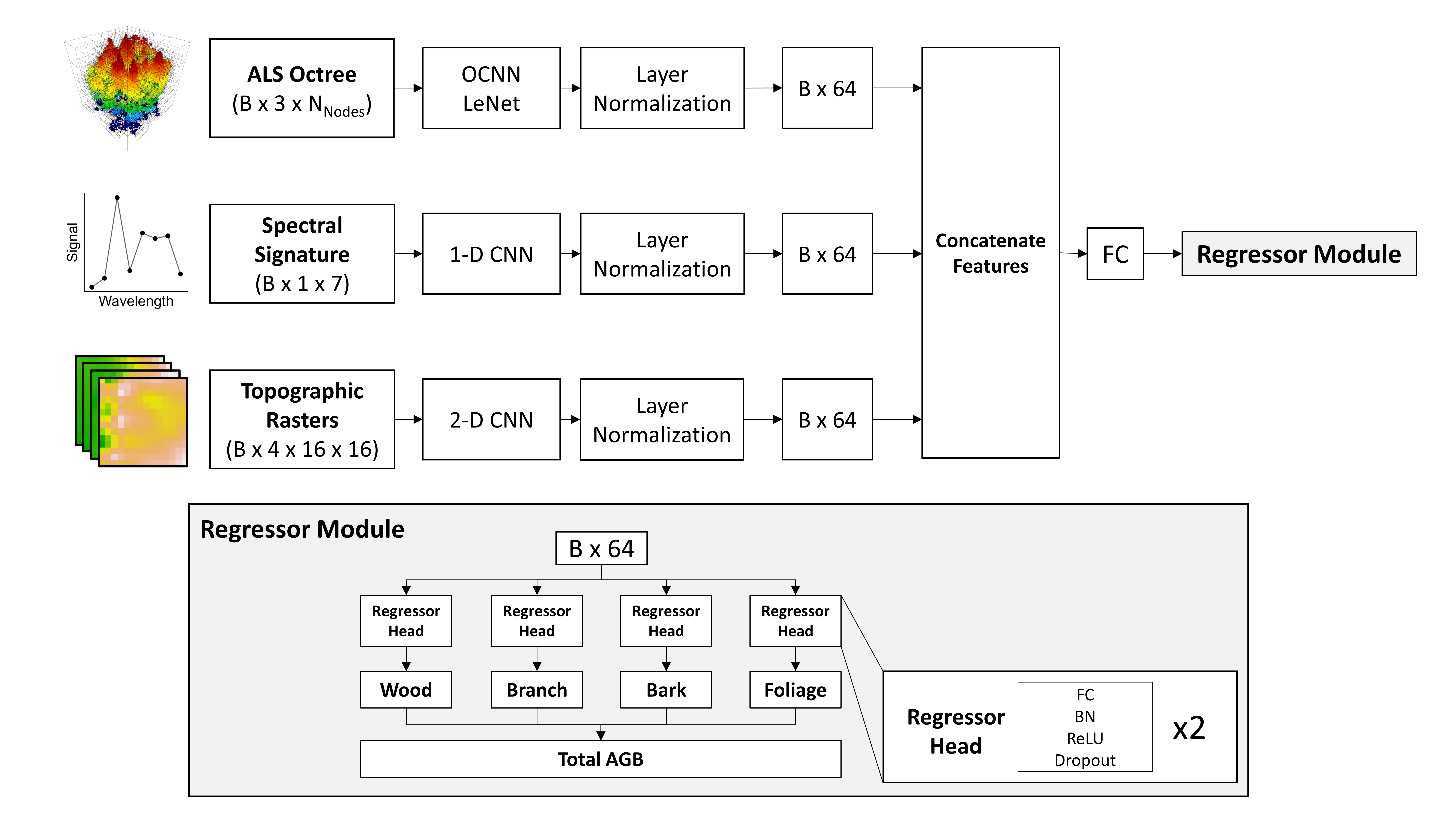
Seely, H., Coops ,Nicholas C., White ,Joanne C., Montwé ,David, and Ragab, A., 2025. Forest aboveground biomass estimation using deep learning data fusion of ALS, multispectral, and topographic data. International Journal of Remote Sensing 0, 1–39. https://doi.org/10.1080/01431161.2025.2492412
Tree Species Proportion Estimation and Classification from Airborne Laser Scanning Data
Murray, B., Coops, N., Winiwarter, L., White, J., Dick, A., Barbeito, I., Ragab, A., 2024. Estimating tree species composition from airborne laser scanning data using point-based deep learning models. ISPRS JOURNAL OF PHOTOGRAMMETRY AND REMOTE SENSING 207, 282–297. https://doi.org/10.1016/j.isprsjprs.2023.12.008
Murray, B.A., Coops, N.C., White, J.C., Dick, A., Barbeito, I., Ragab, A., 2025. Individual tree species prediction using airborne laser scanning data and derived point-cloud metrics within a dual-stream deep learning approach. International Journal of Applied Earth Observation and Geoinformation 144, 104877. https://doi.org/10.1016/j.jag.2025.104877
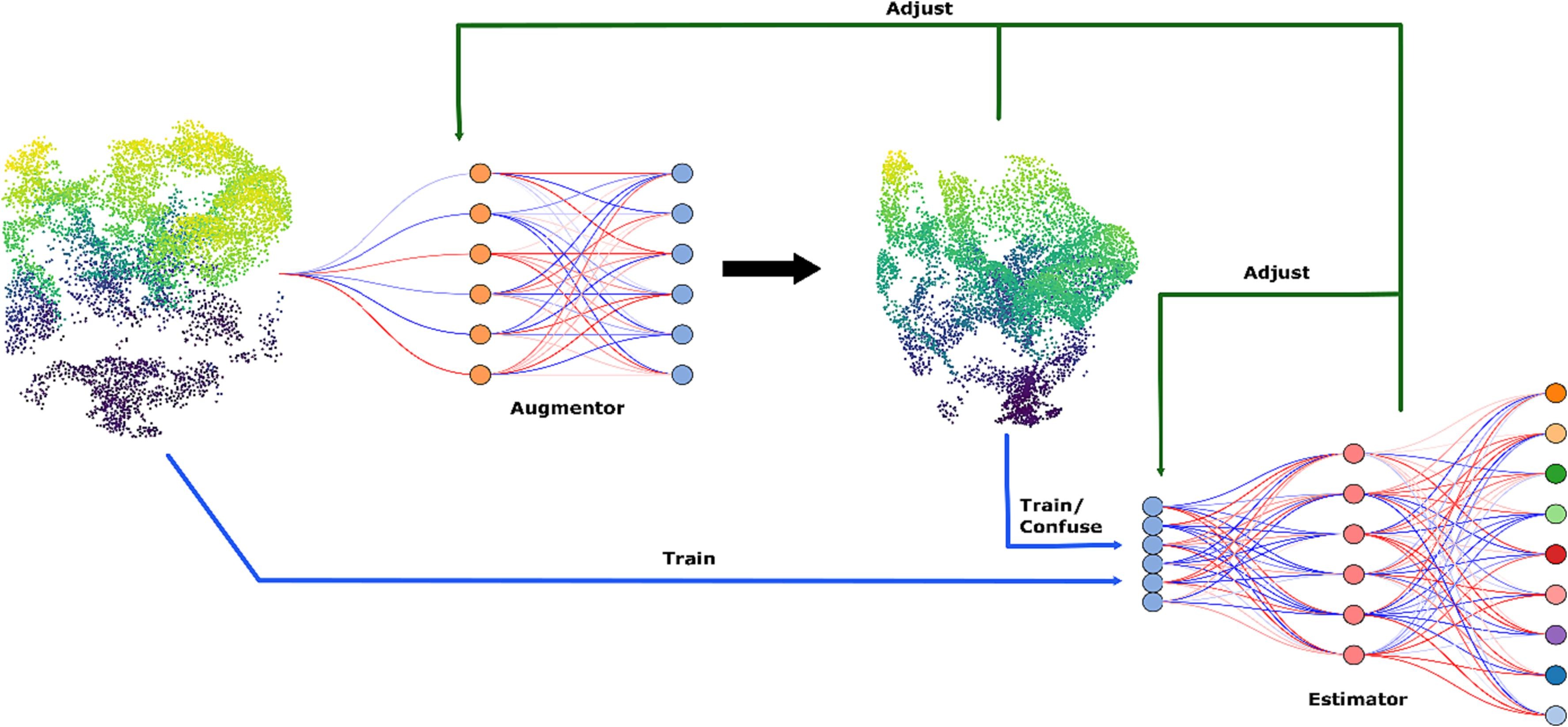
Murray, B.A., Coops ,Nicholas C., White ,Joanne C., Dick ,Adam, and Ragab, A., 2025. Tree species proportion prediction using airborne laser scanning and Sentinel-2 data within a deep learning based dual-stream data fusion approach. International Journal of Remote Sensing 0, 1–29. https://doi.org/10.1080/01431161.2025.2521072
Cao, Y., Coops, N.C., Murray, B.A., Sinclair, I., 2025. Enhancing tree species composition mapping using Sentinel-2 and multi-seasonal deep learning fusion. International Journal of Remote Sensing 1–27. https://doi.org/10.1080/01431161.2025.2583600
Puliti, S., Lines, E.R., Müllerová, J., Frey, J., Schindler, Z., Straker, A., Allen, M.J., Winiwarter, L., Rehush, N., Hristova, H., Murray, B., Calders, K., Coops, N., Höfle, B., Irwin, L., Junttila, S., Krůček, M., Krok, G., Král, K., Levick, S.R., Luck, L., Missarov, A., Mokroš, M., Owen, H.J.F., Stereńczak, K., Pitkänen, T.P., Puletti, N., Saarinen, N., Hopkinson, C., Terryn, L., Torresan, C., Tomelleri, E., Weiser, H., Astrup, R., 2025. Benchmarking tree species classification from proximally sensed laser scanning data: Introducing the FOR-species20K dataset. Methods in Ecology and Evolution 16, 801–818. https://doi.org/10.1111/2041-210X.14503
Extraction of Forest Road Information from High-Resolution Satellite Imagery
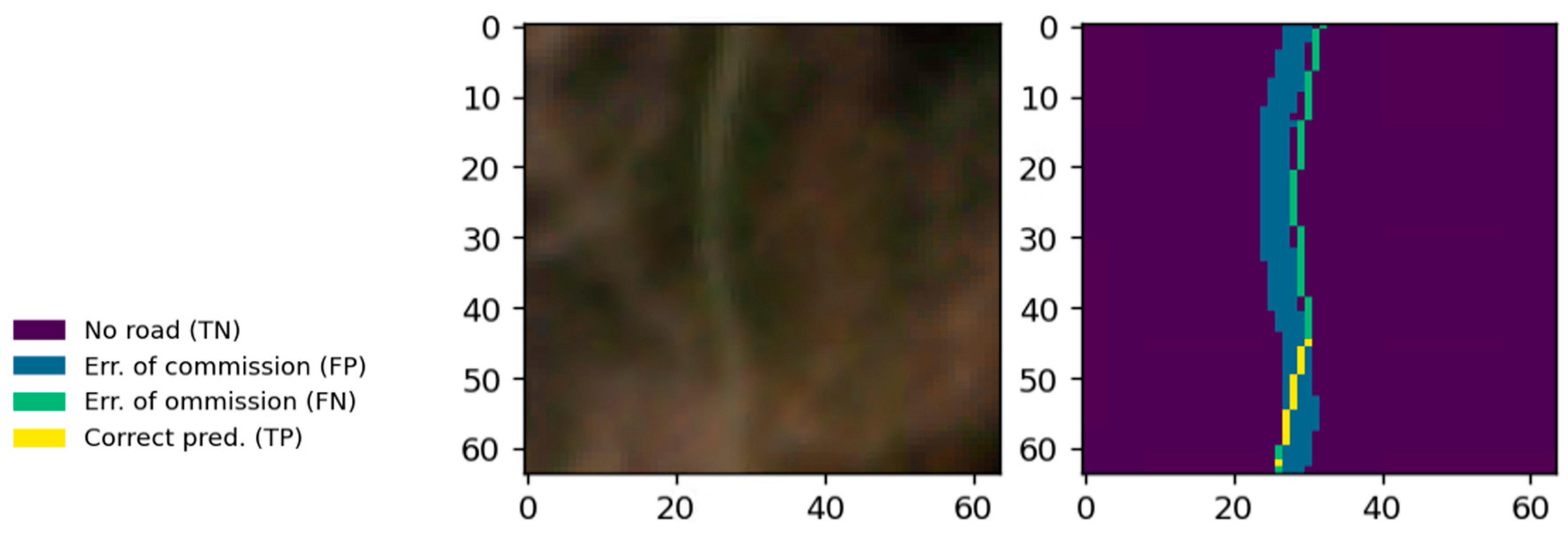
Winiwarter, L., Coops, N.C., Bastyr, A., Roussel, J.-R., Zhao, D.Q., Lamb, C.T., Ford, A.T., 2024. Extraction of forest road information from cubesat imagery using convolutional neural networks. Remote Sensing 16, 1083. https://doi.org/10.3390/rs16061083